If possible, read "Effect of Topography on Regional Flow Systems" (pg. 197) in Groundwater, by Freeze and Cherry.

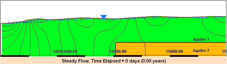
In hummocky terrain, the presence of a basal aquifer creates a highway for flow that passes under the overlying local systems. The existence of a high permeability conduit thus promotes the possibility of regional systems even in areas of pronounced local relief. There is a particular importance to the position within the basin of buried lenticular bodies of high conductivity. Changes in this location (e.g., presence of a partial basal aquifer in the upstream or downstream half of the terrain of the basin) can influence significantly different recharge and discharge relations at the surface.
TASKS:
- Develop a model that can be used to simulate the flow system in a hummocky terrain shown in the figure above, with a basal aquifer (top graphic shown above), using the MAGNET modeling platform.
- Develop a model that can be used to simulate the flow system in a hummocky terrain shown in the figure below, with the presence of a partial basal aquifer in the upstream half of the terrain of the basin (bottom graphic shown above) using the MAGNET modeling platform.
- Develop a model that can be used to simulate the flow system in a hummocky terrain shown in the figure below, with the presence of a partial basal aquifer in the downstream half of the terrain of the basin (similar to the bottom graphic, but move the basal aquifer to the downstream half) using the MAGNET modeling platform.
- Compare your models to those presented in under the Educational Library: Regional Vertical Circulation
- Comment how hidden geology impact groundwater recharge and discharge at the surface in complex ways.
- Comment on what the flow patterns mean for aquifer protection, siting of waste disposal facilities, and identifying/inventorying groundwater dependent ecosystems.
MAGNET/Modeling Hints:
- Use ‘Synthetic mode’ in MAGNET to create a model domain.
- To create a 2D vertical profile model in Synthetic mode, use a line feature and the 'Equal to Y (e.g., Water Table)' option to delineate the water table surface toward the top of the model domain.
- After your initial simulation, you can "clean up" the display by then making the space above the water table inactive with a zone feature ( 'Flow Properties' tab > 'Zone Type' > 'Inactive' ).
- Use a relatively large NX (e.g., 100) to resolve the water table shape.